(Summer 2014) Lee Dwyer, G
Lee Dwyer, (G, Urban Studies and Planning)
Lee spent the summer working with the Dudley Street Neighborhood Initiative in Roxbury, Boston on community mapping and Trina Persad Park redesign projects. He created maps of important community issues like foreclosures and vacant lots, while building future mapping capacity within DSNI and the community. He also supported two of DSNI’s summer youth teams in improving Trina Persad Park and in community engagement efforts.
____________________________________________________________________________________________
Blog Post #1: An Introduction
Hi reader! Here’s the basics on who I am and what I’m doing this summer. Check in soon for more updates…
WHO: My name is Lee Allen Dwyer, and I’m a Master’s in City Planning student in MIT’s Department of Urban Studies and Planning, planning to graduate in May 2015. I’ve lived and worked in the Boston area since 2011, though I was raised in Louisiana.
The organization where I’m interning is called the Dudley Street Neighborhood Initiative. Founded in 1984 by residents seeking to improve the neighborhood, which covers parts of Roxbury, Dorchester, and the South End, the organization remains true to its roots as a strongly community-driven institution.
WHAT: My internship is focused on two main projects: community mapping and working with youth to improve Trina Persad Park, a local play area. Within each of those, my goal is to use the skills I’m learning at MIT–GIS mapping and data analysis, participatory mapping techniques, community engagement, the history of urban development—to help build capacity at DSNI, get community members interested and involved, and hopefully contribute to a better quality of life in the Dudley community.
WHERE: DSNI focuses on a “Dudley Village Campus” overlapping Roxbury and Dorchester, and within that area has stewardship over the Dudley Triangle land trust. This land trust, made up of former vacant lots that once blighted whole blocks, now serves as a stabilizing force and has allowed DSNI to build affordable housing, commercial buildings, urban agriculture sites, and even a playground. You can learn more about the history of the organization and the neighborhood here .
I do most of my work at DSNI’s main office on Dudley Street, in the heart of the neighborhood, though I also work from home or school when there is not enough computer space or when I need help from MIT librarians, computer specialists, or GIS gurus.
WHEN: I began my internship on June 2nd and will work through August 15th.
WHY: This spring, DSNI and DUSP Professor Ceasar McDowell began building a partnership through a practicum class, in which I participated. Two of the projects students undertook during the semester were community mapping and the Trina Persad Park. I wanted to help this relationship continue to grow and to build on the work we’d been doing. Additionally, I saw how much DSNI has already done in the neighborhood—and at the same time, the challenges it and the area’s residents still face. I also admired DSNI’s commitment to thorough community involvement in every aspect of its work, and wanted to help boost that strength even further by creating maps the organization and community can use, paving the way for more interactive mapping and data-gathering, and working with young people to envision an even better neighborhood.
______________________________________________________________________________________
Blog Post #2: Mapping and a School’s Growing Pains
The second project I worked on this summer came from a pressing community need: more classroom seats. A couple doors down from DSNI’s office, in the old Emerson School building, is the Dudley Street Neighborhood Charter School, which currently serves grades K-2. DSNI helped in establishing this community-focused school a few years ago. Kids of staff members, board members, and land trust residents (among others) attend it, and they go on field trips to The Food Project’s urban farm lots, and learn about the history of the neighborhood. But the young school is outgrowing its building, which can’t accommodate additional grades. This means rising third-graders will have to go to other schools–likely outside their neighborhood–get used to new teachers and different school rules, and make new friends.
My internship supervisor asked me to create some maps for a community meeting on June 23rd, which would be attended by over 100 DSNCS parents, kids, and teachers as well as Boston’s Interim Superintendent John McDonough. The maps would show the context of the school in the neighborhood and the school-age population in surrounding census tracts, to visually underline the need for expanding the school. I did so, learning along the way that the Dudley Village area has a disproportionately large school-age population as well as many children soon to be school-age. I also learned from Ros Everdell, Deputy Director at DSNI and a longtime community organizer, which schools have closed, opened, and moved in the two years since the publicly available data I was using was published, which was very helpful.
The meeting took place in the DSNCS cafeteria, its walls bright with posters and murals, packed with residents and further highlighting the need for expansion. We put up four of the maps I’d created, telling a story of the neighborhood and the school at its heart. A few families near the maps curiously examined them as I taped them up; one mom pointed out to her daughter where their home was on the map, and I answered several questions they had about the map. From such interactions I realized, to my chagrin, that the maps needed more street labels—the handful I’d included didn’t provide enough geographic context to anyone who hadn’t spent hours editing the map layers.
We all waited for the superintendent in the stuffy basement room. Pizzas arrived for the families. Half an hour passed. Kids squirmed and grandmothers fanned themselves.
Finally Mr. McDonough arrived, and the meeting began. Second-graders spoke about how much they’d learned, how much they loved their teachers and wanted to stay at the school. Parents and grandparents praised the school for raising their students’ reading levels—and interest in learning. One woman had attended the school when it was still Emerson, a traditional public school, and now her child attended the much-improved charter school; she said it was “like night and day”.

My supervisor used the maps around the walls to add some raw facts and to tell a visual story. He pointed out the other organizations, landmarks, and community assets near the school, like DSNI, the Kroc Community Center, and the historic Shirley-Eustis House; if the charter school had to move to another location, it would lose these supportive institutions. He drew attention to the number of schools outside the neighborhood, the number of kids within it, and other important points from the maps’ data. After the meeting, we gave Superintendent McDonough 8×11 copies of the maps, and he remarked on their value—as did several DSNCS teachers and a couple more parents.

But more importantly to me, this event showed me the potential impact of the maps I’ve worked with DSNI and community members to create. If this neighborhood school wins the city’s support to expand, those maps may have contributed to its success. If those second-graders get to stay in the school where they’re doing so well, and if the neighborhood gains a stable, invested, community-focused school of its own, my work will have a real impact…hopefully stretching far beyond this summer.


______________________________________________________________________________________
Blog Post #3: Mapping as a Creative Means of Community Engagement
Maps can be on the cutting edge of modern technology, incorporating social media data or mobile phone GPS sensors, or they can be extremely simple yet highly useful, like the old, peeling system maps on the T. Sometimes in urban planning, it’s best to combine both high-tech and low-tech approaches. And sometimes logistical limitations mean you have to be creative.

Photo courtesy of Travis Watson, DSNI.
Every year DSNI holds its Annual Meeting, a free, public event at which community members help celebrate the organization’s accomplishments in the past year and the challenges it continues to face, learn about new initiatives and upcoming events, and to get involved. Everyone in the tightly-knit organization helps publicize, set up, and run the event, and youth teams serve a free dinner to everyone who attends—this year, around 200 people. I helped put out chairs on a hot, windy afternoon, since the event was held on the blacktop of the nearby Dudley Street Neighborhood Charter School. I also set up a display about mapping and community engagement.
The wind was so strong, however, that it kept blowing large printed maps off the table, and I had to tape some onto the wall of the school. I also taped another map to a 7-foot-tall Plexiglas board that I used as a low-tech version of an interactive GIS map.

Photo courtesy of Travis Watson, DSNI.
One of the main goals for my internship is to begin building capacity for participatory mapping at DSNI and within the greater Dudley community. This is an area on the border of several neighborhoods and wards, where land has been neglected, contested, and reclaimed by the community, where decades of failed urban renewal, abandonment, dumping, and arson left visible scars on the landscape. By mapping community assets and issues, opportunities and challenges, residents and organizations like DSNI can reshape these spaces, provide a counter-narrative to the stories others tell about their neighborhood, and envision new futures for its people and places.
At the Annual Meeting, I encouraged 50-60 participants to identify neighborhood strengths and problems, writing or drawing their input on the Plexiglas over a map of the area.

Photo courtesy of Travis Watson, DSNI.
Many pinpointed local businesses and organizations—such as Nos Casa, a favorite restaurant, or The Food Project, which runs urban farms, CSAs, and youth programs—while others noted that certain streets had too many potholes, or not enough police patrolling. A longtime resident wrote “grew up playing baseball here” over the Clifford Playground; a woman said there were too many liquor stores along a particular stretch of Blue Hill Ave.

When the board got full, I took photos of the data points and erased it to start all over again. Thirty to forty people contributed 47 unique data points to the map; 30 of them were positive things or locations, while 17 were negative. After the event, I compiled this information digitally, geocoded the addresses, and added the points to a GIS map. I also realized that, in talking to residents, I needed to change the projection of the maps and add more labels to identify major streets and make the map easier to read. You can see the results below.

I also broke the data down into What’s Good (pluses) and What’s Not Good (X’es) to highlight the locations. Click the thumbnails below to see larger versions.


In the short term, this may seem like just a cool GIS exercise, but it’s more than that: it’s a start to getting community members involved in the process of mapping their neighborhood, a means of creative engagement and basic capacity-building. It’s a way to source data from the folks who know these places best, rather than just using pre-existing data from state or city agencies, GIS software programs, or the US Census. And in the long-run, it can be the first step in adding mapping and other forms of data visualization to the community organizing and advocacy that’s already a source of strength, support, and resilience in this neighborhood.
UPDATE 8/5/14: Check out the DSNI home page and Facebook page–the Annual Meeting mapping display is catching some attention!
____________________________________________________________________________________________
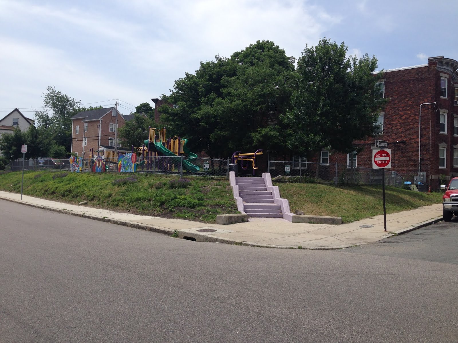
Blog Post #4: Trina Persad Park
In the summer of 2002, a young girl named Trina Persad went to play in a Roxbury park. Gang members opened fire on rivals nearby, and Trina was killed by a stray bullet. In a sad twist of fate, the park where it happened was named after Jermaine Goffigan, a boy killed in 1994 in the same kind of crossfire.


- Left: Trina Persad in 2002; Right: the park where she was killed.
Meanwhile, DSNI and community residents had been working on cleaning up a vacant lot nearby and turning it into a playground. Trina’s killing sharpened their interest in building a safe haven for neighborhood children; the playground could also serve as a powerful memorial to her life. Through donations, volunteer hours, and help from a nationwide playground design organization called KaBOOM!, DSNI built Trina Persad Park–the first playground on the Dudley land trust. It opened in 2004, and is popular with kids from the heavily residential area around it.
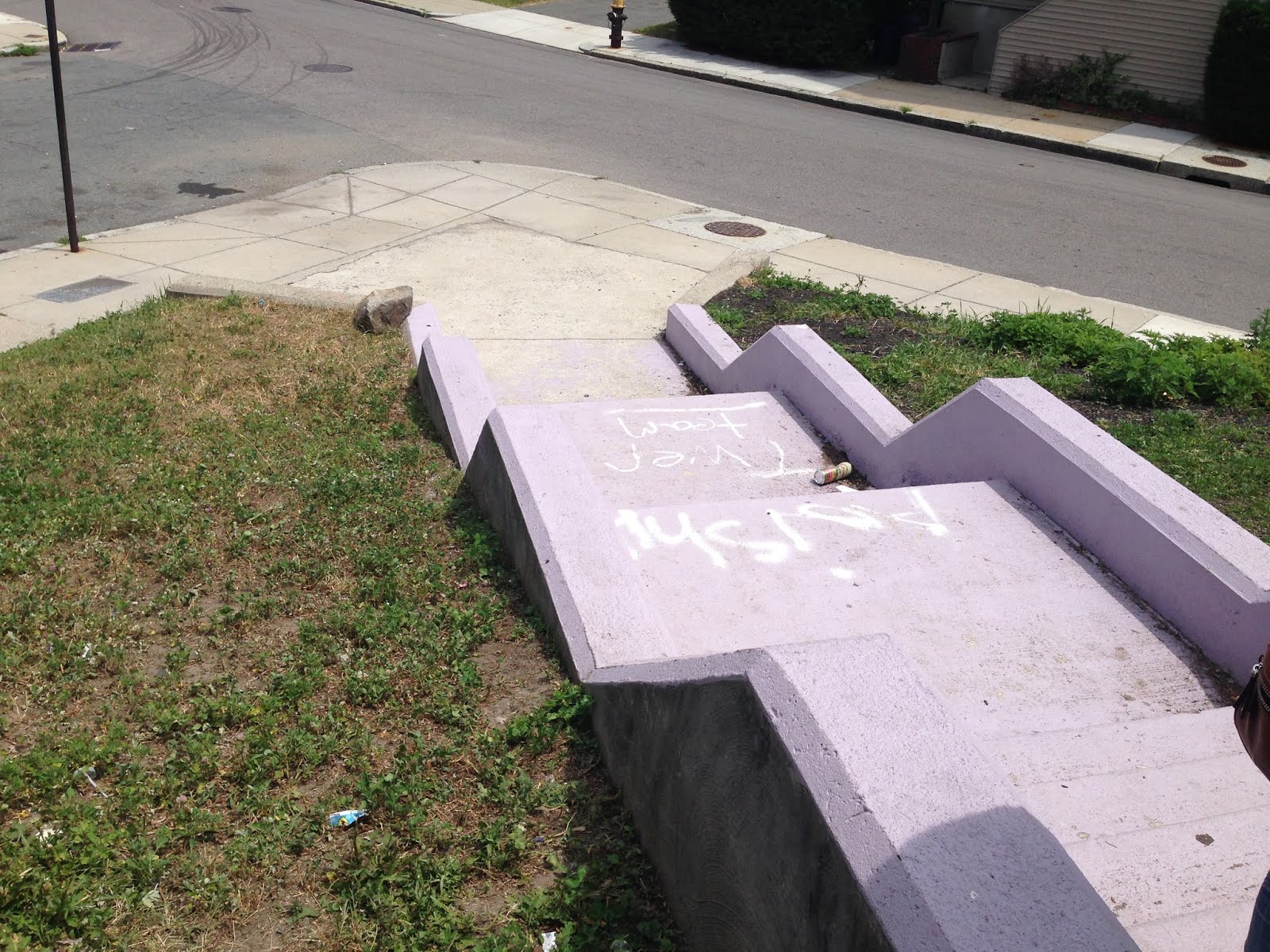
Over the years, the playground has fallen into disrepair: a retaining wall gave way on the park’s eastern side, trash and weeds are a recurring problem, and graffiti mars a few surfaces. Last summer, one of DSNI’s youth teams worked on beautifying the park, painting murals that depict the neighborhood’s character and the legacy of Trina. However, the space still lacks a sign with the park’s name, and the main entrance is unornamented and bare. As part of a spring practicum, my team had identified several design recommendations, such as adding signage and drawing attention to this entrance, perhaps using an archway.
This summer, the youth on the Park Team liked those recommendations; they decided to create an arching sign officially naming the park and welcoming visitors through the main entrance. I helped the team members learn about archways, bringing books from MIT and giving some background information. I also helped them think about the park space and brainstorm design ideas, which the youth ultimately developed into scale models. One young woman, inspired by a book on Islamic architecture that I’d brought, incorporated a rounded triple arch into her model design.
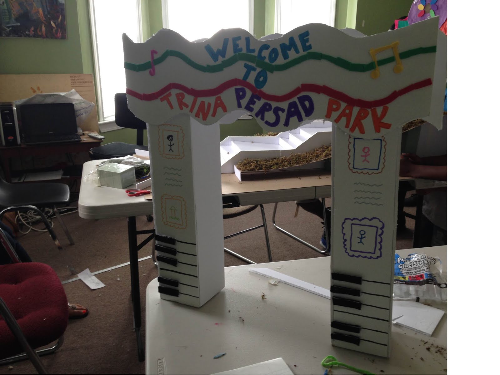
One challenge I’ve encountered with this project, however, is that the Park Team already has a lot of capable help. The leaders of the team, as well as Kate Balug, an artist who’s working with them on several projects, have done a fantastic job running the youths’ day-to-day activities. I didn’t get to be as involved as I originally wanted, because sometimes my assistance seemed a little redundant. Also, sometimes my other projects didn’t work with their schedule, which often changed at the last minute due to weather, space limitations, and other needs. However, I’m happy that I was able to help get them started on the archway, provide some additional ideas and inspiration, and see how it’s all turned out. This Monday the Park Team gave their final presentation to the entire DSNI staff and the other youth teams, and the unveiling of the archway is set for the end of the week. I look forward to seeing how they memorialize Trina and connect the playground to the rest of the neighborhood, its past troubles and future hopes.
____________________________________________________________________________________________
Blog Post #5: Teaming Up with Local Youth
One of the final projects I worked on this summer was teaching youth on the Food Team how to map information they had gathered on healthy food access. They had gone out and surveyed convenience stores in the neighborhood, noting how many types of produce and other healthy foods each store offered. I ran a basic mapping workshop with the whole team, introducing them to GIS and mapping concepts; they all had great responses, questions, and ideas. Then I worked with two youth in particular, Jamal and José, to set up the map using CartoDB, an easy-to-use online program that allows users to create interactive maps.

Food Team members Jamal (left) and José (right) working on the “Snack Attack Map”.

Me (left) working with José (right) on the Food Team’s “Snack Attack Map” design.
Both young men gained skill quickly, and with little prompting, they came up with strong design ideas and creative suggestions. José in particular had a good eye for color, an important feature of most maps. The Food Team included a static copy of the map in a printed brochure on healthy food access, which they distributed to local organizations, health centers, and businesses. The map can be viewed online here (http://cdb.io/XJteXa) or below, and will hopefully be added to the DSNI website soon; click on a point to see more information about that store.
The other youth team I worked with, the Trina Persad Park Team, did not manage to unveil the completed full-scale archway in time due to logistical and weather-related delays. However, they did deploy “The Big Zipper”–a 20-foot inflatable community engagement structure–once more in a vacant lot on Dudley Street, to present the final models for the archway and to get additional community feedback.


Park Team member Shamari with the top section of the archway to be installed at the local park, designed and built by him and his team.
____________________________________________________________________________________________
Blog Post 6: Wrapping Up
With summer coming to an end, I wrapped up my internship at DSNI recently. All in all, I had a fantastic internship and loved getting to know staff, board members, youth, and community members. I was blown away by the talent, passion, friendliness, and dedication of everyone I met in the Dudley area. On my last day my main supervisor, Tony, and the office manager, Erika, threw a surprise goodbye party with pastries, fruit, and notes from staff members written in marker on the “Dudley Visioning Window”, the mapping display I’d used at community events!

A thoughtful and creative farewell from DSNI staff
My experience working with Dudley-area youth over the summer was rewarding, though I didn’t get to engage with them as much or as directly as I originally intended. However, that was partly due to the fact that my mapping work took on more significance and time; there seemed to be a much greater need at DSNI and within the neighborhood for useful maps and map-related community engagement, so I adjusted accordingly. While at first I struggled some with logistical and technological issues, getting settled in, and getting access to data needed for mapping, I persevered and worked around problems as best I could. The most important lesson I learned was to ask questions whenever I needed help.
As for the mapping accomplishments: I completed dozens of maps for eight different projects, plotted and printed copies–including one of the land trust and vacant lots that Tony immediately put up in the office for reference–and set up a detailed data structure with thorough “READ ME” how-to files for whoever works on maps next at DSNI. I trained key staff members in using this data structure as well, incorporating their suggestions, and began building mapping capacity among youth team members (see previous post). Also, I talked with over a hundred community members using the interactive mapping display, and created crowd-sourced maps of the area’s assets and issues with 140 points they identified (see post #3).
I hope to return to the neighborhood, perhaps to support Professor McDowell’s practicum partnering with DSNI again this schoolyear. But even if I don’t get to go back, I structured my work to be useful beyond this summer; I tried hard to increase map usage, to build mapping capacity and to facilitate future capacity-building, and managed to do all of those. It was a very good start, but plenty still remains to be done.
Thanks for reading!